 |
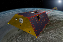
The Gravity Recovery and Climate Experiment Follow-On (GRACE-FO) mission, a joint partnership between NASA and the German Research Centre for Geosciences (GFZ), launched on 22 May 2018. It uses twin satellites to accurately map variations in the Earth's gravity field and surface mass distribution. It is designed as a successor to the Gravity Recovery and Climate Experiment (GRACE) mission.
Conceptually very similar to the original GRACE mission (2002 – 2017), GRACE-FO consists of two identical satellites flying in formation around Earth at an... |
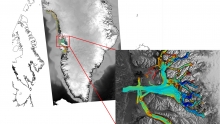 |
Oceans Melting Greenland (OMG) is a NASA Earth Venture Suborbital (EVS-2) mission that aims to improve estimates of sea level rise by addressing the question: To what extent are the oceans melting Greenland’s ice from below? OMG observes changing water temperatures on the continental shelf surrounding Greenland, and how marine glaciers react to the presence of warm, salty Atlantic Water. The complicated geometry of the sea floor steers currents on the shelf and often determines whether Atlantic Water can reach into the long narrow fjords and interact with the coastal glaciers. Because knowledge of these pathways is a critical component of... |
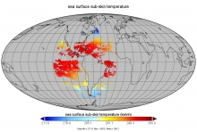 |
GOES-16 (G16) is the first satellite in the US NOAA third generation of Geostationary Operational Environmental Satellites (GOES), a.k.a. GOES-R series (which will also include -S, -T, and -U). G16 was launched on 19 Nov 2016 and initially placed in an interim position at 89.5-deg W, between GOES-East and -West. Upon completion of Cal/Val in Dec 2018, it was moved to its permanent position at 75.2-deg W, and declared NOAA operational GOES-East on 18 Dec 2018. NOAA is responsible for all GOES-R products, including Sea Surface Temperature (SST) from the Advanced Baseline Imager (ABI).
The Level 2 Preprocessed (L2P) SST product is derived at... |
 |
The Gravity Recovery and Climate Experiment Follow-On (GRACE-FO) mission, a joint partnership between NASA and the German Research Centre for Geosciences (GFZ), launched on 22 May 2018. It uses twin satellites to accurately map variations in the Earth's gravity field and surface mass distribution. It is designed as a successor to the Gravity Recovery and Climate Experiment (GRACE) mission.
Conceptually very similar to the original GRACE mission (2002 – 2017), GRACE-FO consists of two identical satellites flying in formation around Earth at an... |
 |
The SPURS (Salinity Processes in the Upper Ocean Regional Study) project is a NASA-funded oceanographic process study and associated field program that aim to elucidate key mechanisms responsible for near-surface salinity variations in the oceans. SPURS employs a suite of state-of-the-art in-situ sampling technologies that, combined with remotely sensed salinity fields from the Aquarius/SAC-D, SMAP and SMOS satellites, provide a detailed characterization of salinity structure over a continuum of spatio-temporal scales. While SPURS-1 focused on the salinity maximum region of the sub-tropical N.... |
 |
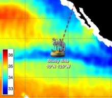
Saildrone is a state-of-the-art, wind and solar powered unmanned surface vehicle (USV) capable of long distance deployments lasting up to 12 months. This novel sampling platform, that is wind propelled but may be guided remotely from land, is equipped with a suite of instruments providing high quality, georeferenced, near real-time, multi-parameter surface ocean and atmospheric observations while transiting at typical speeds of 3-5 knots. During the Baja campaign, a single deployed Saildrone was equipped with a suite of instruments that included a CTD, IR pyrometer, fluorometer,... |
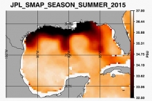 |
The JPL SMAP Version 4.0 datasets spans the full mission, with data available from 2 April 2015 to present. Global coverage data products include an 8-day running mean as well as monthly averages. Level 2 swath data are also available as part of the product release. They are available with a latency of 3 days for the L2 dataset, and 8 days and 1 month for the respective L3 products. The spatial resolution of the SMAP sensor, approximately 40 km, allows for improved applications to coastal and regional studies. The image shows the seasonal average surface salinity for the summer of 2015. Clearly visible is the freshwater plume that is... |
 |
The JPL GRACE Mascon Ocean, Ice, and Hydrology Equivalent Water Height (hereafter, Mascon) products are now available as part of the Tellus MEaSUREs collection of Earth System Data Records (ESDRs). This data product differs from other GRACE data products in that the gravity field has been solved for in terms of equal-area 3-degree spherical cap Mascon solutions, rather than spherical harmonic coefficients. The data product contains monthly global water storage anomalies relative to a time-mean expressed on a 0.5 by 0.5 degree (latitude by longitude) grid, although the native resolution is still limited to 3 by 3 degrees.
Mascon has... |
 |
The Reconstructed Sea Level dataset contains sea level anomalies derived from satellite altimetry and tide gauges. Since 1993, satellite altimetry has provided accurate measurements of sea surface height with near-global coverage. These measurements led to the first definitive estimates of global mean sea level (GMSL) rise and have improved understanding of how sea levels are changing regionally at decadal time scales These relatively short records, however, provide no information about the state of the ocean prior to 1993, and with the modern altimetry record spanning only 20 years, the lower-frequency signals that are known to be present... |
 |
PO.DAAC is pleased to announce that it will distribute three gridded satellite datasets to facilitate climate model evaluation. They include variables for Sea Surface Temperature (SST), Absolute Dynamic Topography (ADT), and ocean surface vector winds. These observational datasets are on monthly 1° grids with various time series lengths. They were generated with the initial intention to facilitate the intercomparison of satellite derived observations with climate model outputs from CMIP5 (Coupled Model Intercomparison Project Phase 5) under the World Climate Research Program (WCRP). However, their utility extends beyond climate model... |