
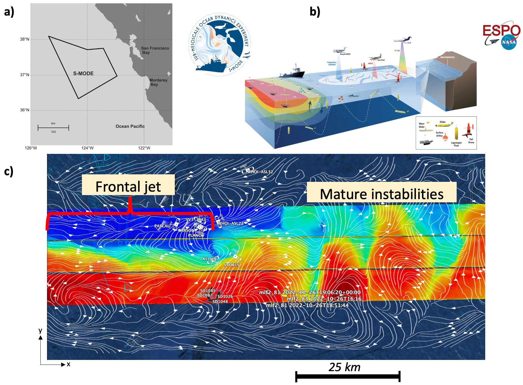
The Sub-Mesoscale Ocean Dynamics Experiment (S-MODE) (Farrar et al., 2020) is a NASA Earth Ventures Suborbital Investigation designed to test the hypothesis that kilometer-scale (“submesoscale”) ocean eddies make important contributions to vertical exchange of climate and biological variables in the upper ocean. To test this hypothesis, S-MODE has conducted two intensive operating periods (IOPs) in the open ocean ~150 km west of San Francisco, California (Figure 1a): IOP1 covers the period from October 5 to November 3, 2022, IOP2 covers the period from April 3 to May 3, 2023. The four science objectives include: 1) measuring the three-dimensional structure of the submesoscales dynamics responsible for vertical exchange; 2) quantify the role of air-sea interaction and surface forcing; 3) understand the relation between the ocean velocity measured by remote sensing at the surface and that just below the surface boundary layer; and 4) diagnose dynamics of vertical transport processes. One novel aspect of S-MODE is its direct observations of horizontal velocities and their gradients using the airborne DopplerScatt as well as in situ platforms (top panel in Figure 1b). The combination of all assets provides an unprecedented vision into ocean physics and ocean biology at ocean submesoscales (100 m - 10 km).
The intimate connection between mesoscale and submesoscale ocean motions is revealed by the simultaneous surface currents (streamline) and sea surface temperature (SST) measurements (Figure 1c). The former was collected by the NASA-JPL DopplerScatt (Doppler scatterometry, Rodriguez et al., 2018) and latter by the UCLA MOSES (Multiscale Observing System of the Ocean Surface). The DopplerScatt instrument is capable of simultaneously measuring surface ocean currents and equivalent neutral winds, while the MOSES instrument measures SST. These instruments are mounted on a NASA King Air B200 aircraft, allowing them to generate a nearly synoptic map covering a 100-by-100-km area in a single 4-hour flight.
Figure 1c displays the DopplerScatt surface currents (streamlines) and MOSES SST (color) during IOP1. On the western side of the map, a distinct front is observed, separating warm waters (red colors) from cold waters (blue colors). This front is a result of the interaction between two mesoscale eddies: a cyclonic eddy to the north and an anticyclonic eddy to the south. On the eastern side of the map, a submesoscale eddy creates a wave-like pattern with a wavelength of 20 km. The streamlines of ocean currents correspond to the SST distribution, with a nearly zonal submesoscale front on the west side and curved streamlines following the wave-like pattern in SST on the east side. The interaction between mesoscale eddies compresses and elongates the SST front, resulting in a sharper front. However, the emergence of a small-scale front hinders the ability of mesoscale eddies to further enhance the sharpness. These ocean features pose challenges for in-situ measurements (e.g., shipboard, gliders, buoys) due to their rapid spatial and temporal evolution.
The combination of DopplerScatt and MOSES measurements on the aircraft provides a nearly synoptic view that is well-suited to address the challenges posed by submesoscale ocean motions. The integration of these aircraft-based remote sensing data with in-situ measurements from the S-MODE project offers a unique dataset to validate or refute theoretical and numerical studies focused on submesoscales over the past 15 years. It contributes to advancing our understanding of the dynamic and small-scale ocean features in the upper ocean, which exhibit rapid changes. Most importantly, these datasets and science to be revealed will pave the way to the future ocean currents satellite mission such as the Ocean DYnamics and Surface Exchange with the Atmosphere (ODYSEA) mission.