
Arctic sea ice has dramatically decreased in extent and thickness over the past few decades, consistent with global warming predictions1. Antarctic sea ice has also been experiencing a decline, particularly since 2016, with recent years showing record low extents2. Not only is the loss of sea ice a consequence of a warming climate, less sea ice means less planet-warming sunlight is reflected back into space. Additionally, sea ice is an essential habitat for wildlife in the Arctic Ocean, offering spaces for resting, birthing, and hunting3.
Since the 2000s, measurements from dedicated satellite altimeter missions such as ICESat (Ice, Cloud, land Elevation Satellite), CryoSat-2 and more recently ICESat-2, have provided an unprecedented record of the temporal and spatial patterns of sea ice thickness change. Nevertheless, the observational record still has considerable gaps.
Since its successful launch on December 16, 2022, the NASA/CNES Surface Water Ocean Topography (SWOT) satellite mission has been capturing the elevation of water at unprecedented spatial scales both over the ocean (sea surface height (SSH)) and inland over lakes, rivers, and wetlands. Unlike previous altimeter missions, SWOT carries the first wide-swath Ka-band interferometric altimeter (KaRIn), which for the first time, can provide two-dimensional mapping of surface topography at high resolution up to 78°S/N. Although SWOT was not specifically designed to monitor sea ice, it was recently discovered that SWOT holds the potential to significantly contribute to polar science and our understanding of the fast-changing sea ice systems4.
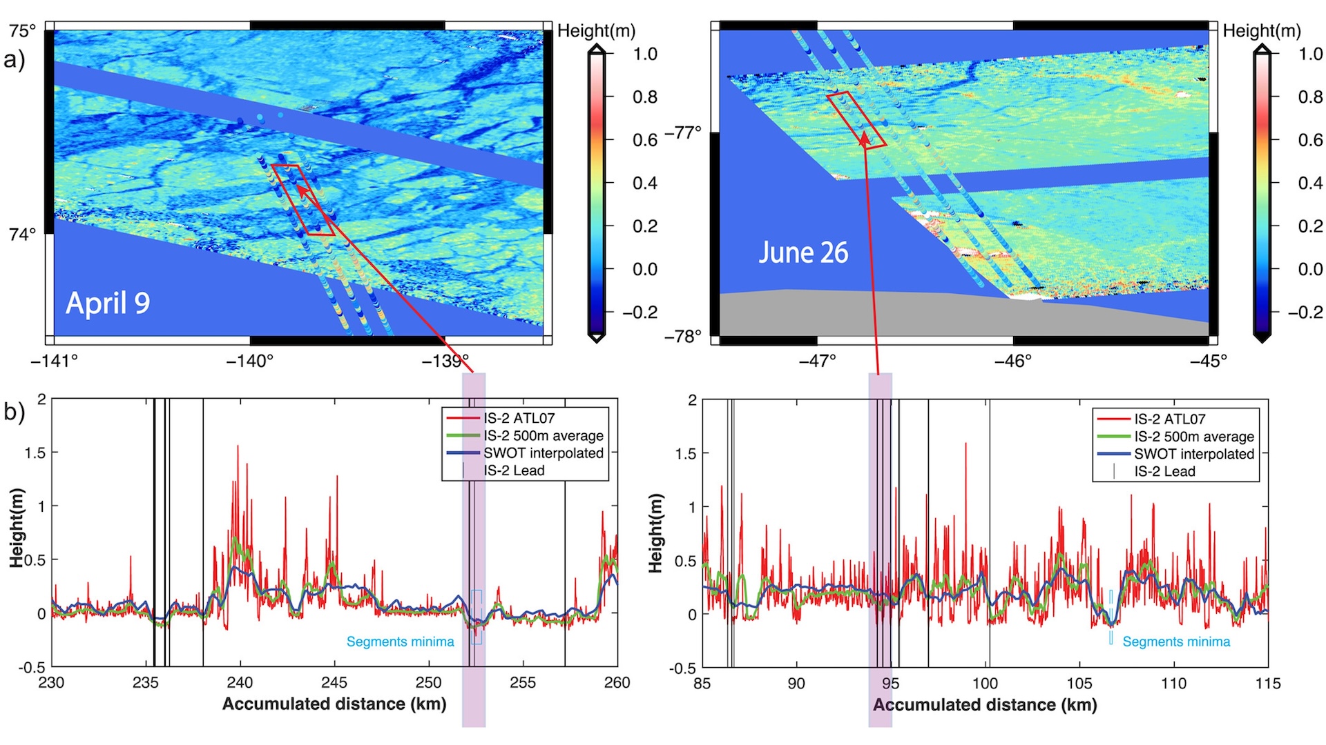
A recent study4 compares measurements of sea ice surface heights from ICESat-2 and SWOT. The along-track surface heights from both satellites align closely (Figure a) on two specific days in the Arctic (left) and Antarctic (right). Figure b displays the along-track surface heights from ICESat-2 (at the varying native resolution of ~17-200 meters in red and averaged over 500 meters in green) alongside the corresponding SWOT surface elevation (in blue). This illustrates the strong consistency between the two independent instruments providing added fidelity of the satellite observations. The purple shaded areas in Figure b highlight regions of identified leads (i.e., cracks within the ice cover, where the underlying ocean is exposed) captured by both ICESat-2 and SWOT. ICESat-2 and SWOT sea ice freeboards—the height of snow and ice above the waterline—are also similar for both case studies in the Arctic and Antarctic.
This study underscores SWOT’s potential to provide two-dimensional estimates of sea ice thickness—essential to quantify exchanges between sea ice, the atmosphere, and the ocean, which current altimeters cannot provide. SWOT sea ice measurements can also support applications that demand greater spatial coverage and more frequent sampling, including process studies, seasonal forecasting, and navigation.