
IMPORTANT UPDATE: We are in the process of migrating this PO.DAAC website into Earthdata. Thank you for your patience as we make this transition. Read about the Web Unification Project. 

Jet Propulsion Laboratory California Institute of Technology
Home

PO.DAAC

Follow Us

Navigation

  • Home
  • Find Data
    • Science Disciplines
      • Ocean
      • Cryosphere
      • Terrestrial Hydrosphere
    • Measurements
      • Glaciers/Ice Sheets
      • Gravity/Gravitational Field
      • Ocean Circulation
      • Ocean Heat Budget
      • Ocean Surface Topography
      • Ocean Temperature
      • Ocean Waves
      • Ocean Winds
      • Salinity/Density
      • Sea Ice
      • Surface Water
    • Missions
      • ADEOS-II
      • AQUA
      • AQUARIUS/SAC-D
      • CCMP
      • COWVR-TEMPEST
      • CYGNSS
      • ECCO
      • GEOS-3
      • GHRSST
      • GRACE
      • GRACE-FO
      • ISS-RAPIDSCAT
      • JASON 1
      • JASON 3
      • MEASURES-MUR
      • MEASURES-OSVW
      • MEASURES-PRE-SWOT
      • NASA-SSH
      • NSCAT
      • OMG
      • OPERA
      • OSTM-JASON 2
      • QUIKSCAT
      • S-MODE
      • S-NPP
      • SASSIE
      • SEASAT
      • SENTINEL-6
      • SMAP
      • SPURS
      • SWOT
      • TERRA
      • TOPEX-POSEIDON
  • Access Data
  • RESOURCES
    • Cloud Data Users
    • Data Providers
  • About
    • ABOUT Us
      • ABOUT PO.DAAC
      • Data Use and Citation Policy
    • MEASUREMENTS
      • Glaciers/Ice Sheets
      • Gravity/Gravitational Field
      • Ocean Circulation
      • Ocean Heat Budget
      • Ocean Surface Topography
      • Ocean Temperature
      • Ocean Waves
      • Ocean Winds
      • Salinity/Density
      • Sea Ice
      • Surface Water
    • MISSIONS
      • ADEOS-II
      • AQUA
      • Aquarius/SAC-D
      • CCMP
      • COWVR-TEMPEST
      • CYGNSS
      • ECCO
      • GEOS-3
      • GHRSST
      • GRACE
      • GRACE-FO
      • ISS-RapidScat
      • JASON 1
      • JASON 3
      • MEaSUREs-MUR
      • MEaSUREs-OSVW
      • MEaSUREs-Pre-SWOT
      • NASA-SSH
      • NSCAT
      • OMG
      • OPERA
      • OSTM - JASON 2
      • QuikSCAT
      • S-MODE
      • S-NPP
      • SASSIE
      • Seasat
      • Sentinel-6
      • SMAP
      • SPURS
      • SWOT
      • TERRA
      • TOPEX-POSEIDON
    • NEWS
      • Announcements
      • Events
      • Meetings and Workshops
      • System Alerts
  • HELP
    • Mailing List
    • Forum
    • PO.DAAC RSS Feeds
  • CLOUD DATA
    • ABOUT
    • Cloud Datasets
    • Access Data
    • FAQ
    • Resources
    • Migration

You are here

Home

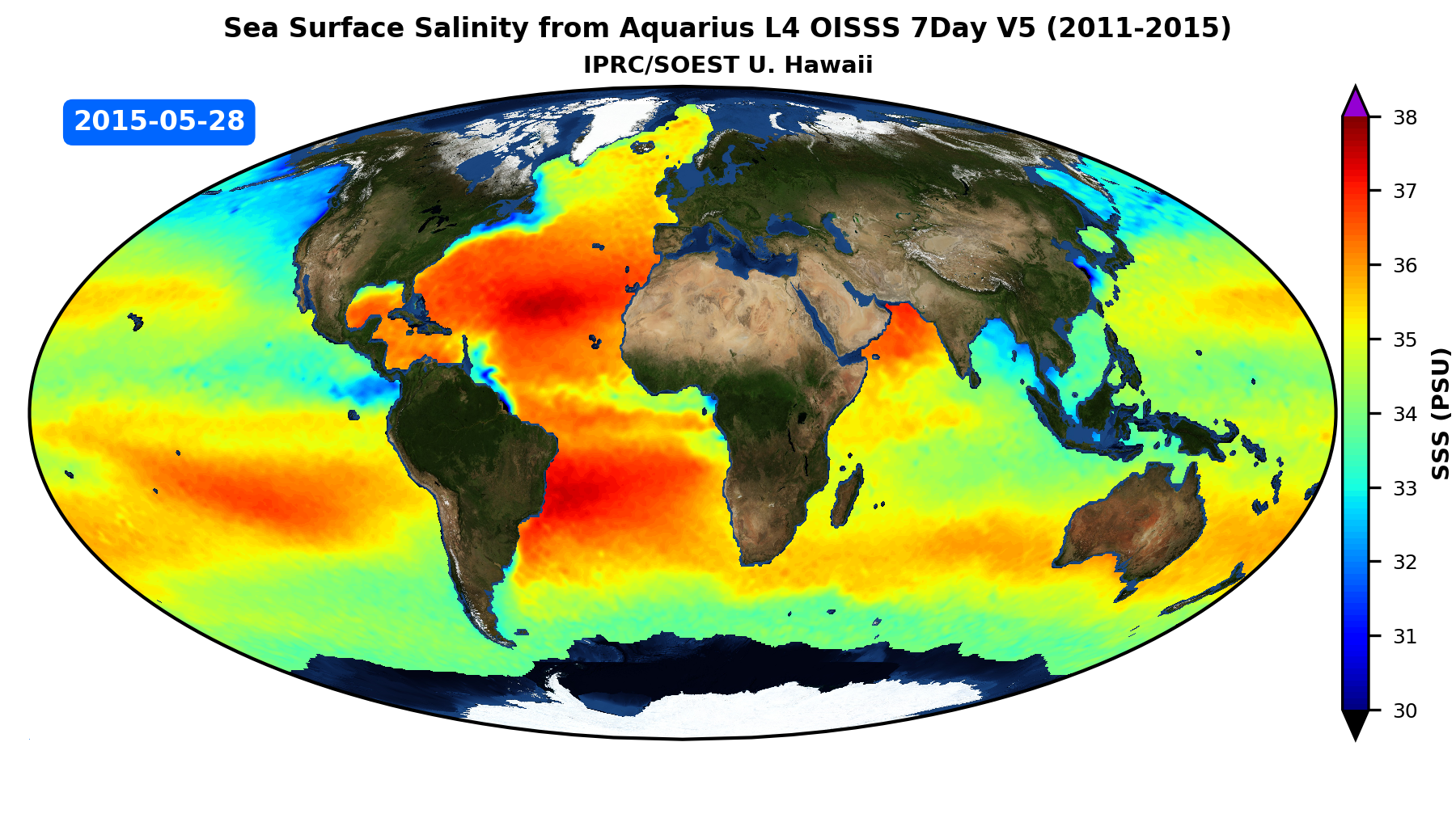
IPRC/SOEST Optimally Interpolated Sea Surface Salinity (OISSS) Aquarius V5.0 Animation

Frontpage

Animation of global sea surface salinity (SSS) over the period 27-08-2011 to 14-05-2015 based on the Aquarius OI-SSS Level 4 7Day version 5.0 product from the International Pacific Research Center of University of Hawaii (IPRC). The dataset can be downloaded from PODAAC Portal at https://podaac.jpl.nasa.gov/dataset/AQUARIUS_L4_OISSS_IPRC_7DAY_V5
 

Link: 
https://podaac.jpl.nasa.gov/animations/IPRC_SOEST_OISSS_Aquarius_V5-0_Animation
IPRC/SOEST Optimally Interpolated Sea Surface Salinity (OISSS) Aquarius V5.0 Animation
  • RSS Feed
  • Privacy
  • Data Citation
  • About PO.DAAC
  • Contact
PODAAC Core Trust Seal
Get PO.DAAC Updates by Email Subscribe »
Clearance Number: CL05-0770
top
Back to top