Jet Propulsion Laboratory California Institute of Technology
Home

PO.DAAC

Follow Us

Navigation

  • Home
  • Find Data
    • Science Disciplines
      • Ocean
      • Cryosphere
      • Terrestrial Hydrosphere
    • Measurements
      • Glaciers/Ice Sheets
      • Gravity/Gravitational Field
      • Ocean Circulation
      • Ocean Heat Budget
      • Ocean Surface Topography
      • Ocean Temperature
      • Ocean Waves
      • Ocean Winds
      • Salinity/Density
      • Sea Ice
      • Surface Water
    • Missions
      • ADEOS-II
      • AQUA
      • AQUARIUS/SAC-D
      • CCMP
      • COWVR-TEMPEST
      • CYGNSS
      • ECCO
      • GEOS-3
      • GHRSST
      • GRACE
      • GRACE-FO
      • ISS-RAPIDSCAT
      • JASON 1
      • JASON 3
      • MEASURES-MUR
      • MEASURES-OSVW
      • MEASURES-PRE-SWOT
      • NASA-SSH
      • NSCAT
      • OMG
      • OPERA
      • OSTM-JASON 2
      • QUIKSCAT
      • S-MODE
      • S-NPP
      • SASSIE
      • SEASAT
      • SENTINEL-6
      • SMAP
      • SPURS
      • SWOT
      • TERRA
      • TOPEX-POSEIDON
  • Access Data
  • RESOURCES
    • Cloud Data Users
    • Data Providers
  • About
    • ABOUT Us
      • ABOUT PO.DAAC
      • Data Use and Citation Policy
    • MEASUREMENTS
      • Glaciers/Ice Sheets
      • Gravity/Gravitational Field
      • Ocean Circulation
      • Ocean Heat Budget
      • Ocean Surface Topography
      • Ocean Temperature
      • Ocean Waves
      • Ocean Winds
      • Salinity/Density
      • Sea Ice
      • Surface Water
    • MISSIONS
      • ADEOS-II
      • AQUA
      • Aquarius/SAC-D
      • CCMP
      • COWVR-TEMPEST
      • CYGNSS
      • ECCO
      • GEOS-3
      • GHRSST
      • GRACE
      • GRACE-FO
      • ISS-RapidScat
      • JASON 1
      • JASON 3
      • MEaSUREs-MUR
      • MEaSUREs-OSVW
      • MEaSUREs-Pre-SWOT
      • NASA-SSH
      • NSCAT
      • OMG
      • OPERA
      • OSTM - JASON 2
      • QuikSCAT
      • S-MODE
      • S-NPP
      • SASSIE
      • Seasat
      • Sentinel-6
      • SMAP
      • SPURS
      • SWOT
      • TERRA
      • TOPEX-POSEIDON
    • NEWS
      • Announcements
      • Events
      • Meetings and Workshops
      • System Alerts
  • HELP
    • Mailing List
    • Forum
    • PO.DAAC RSS Feeds
  • CLOUD DATA
    • ABOUT
    • Cloud Datasets
    • Access Data
    • FAQ
    • Resources
    • Migration

You are here

Home

Data in Action: Sea Level satellites monitor how this year’s El Niño is shaping up

Frontpage

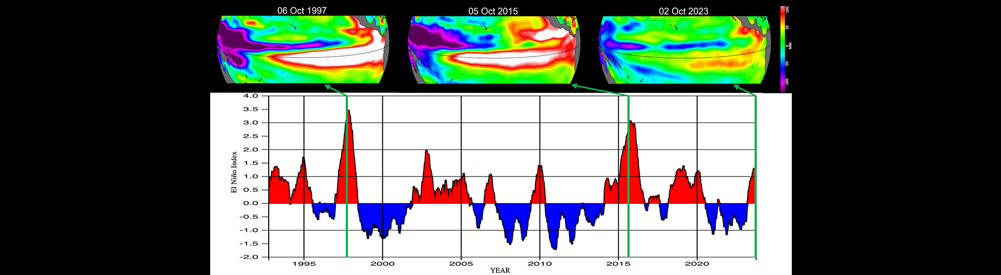
El Niño-Southern Oscillation (ENSO) is a periodic climate pattern in the Pacific Ocean that can have consequences on fisheries in South America and bring cooler, wetter conditions to the U.S. Southwest and drought to countries in Indonesia and Australia.

Link: 
https://podaac.jpl.nasa.gov/DataAction-2022-10-31-Sea-Level-satellites-monitor-h…
This graphic illustrates in figure 1 shows sea level anomalies (SLA) measurements from the TOPEX/Poseidon, Jason-3, and Sentinel-6 Michael Freilich mission in the beginning of October 1997, 2015, and 2023, respectively. Figure 2 shows the El Niño sea level-based index developed by Hamlington et al. (2019). It confirms that this year’s event’s effect on sea level is much more modest than in 1997 or 2015 as of October.
  • RSS Feed
  • Privacy
  • Data Citation
  • About PO.DAAC
  • Contact
PODAAC Core Trust Seal
Get PO.DAAC Updates by Email Subscribe »
Clearance Number: CL05-0770
top
Back to top