 |
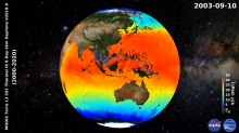
NASA OBPG/JPL MODIS L2P/L3 SST v2019.0 Datasets ReleaseThe recent R2019.0 processing of the Aqua/Terra Moderate-resolution Imaging Spectroradiometer (MODIS) Sea Surface Temperature (SST) data by NASA's Ocean Biology Processing Group (OBPG) has made significant improvements from the previous R2014.0 SST version. This new version has incorporated several enhancements, including a revised cloud classification scheme based on the theory of Alternating Decision Trees (ADtree) developed by Freund and Mason 1999 and modified by Pfahringer et. al. 2000, improved day and night cloud identification using ADTrees (Kilpatrick et. al 2019), and a night time Saharan dust index and aerosol correction for the... |
 |
MEaSUREs Pre-SWOT Hydrology Datasets ReleaseThe MEaSUREs Pre-Surface Water and Ocean Topography (SWOT) Hydrology datasets provide time series of river and lake/reservoir heights, lake/reservoir storage, and grids of lake/reservoir surface area. These 5 datasets are derived from ERS-1 & 2, TOPEX/Poseidon, Jason-1, 2 & 3 and MODIS on Aqua and Terra measurements, and are provided as time series for virtual gauges or grids of surface area extent. The intent is to provide satellite data for hydrological measurements that are typically measured from in situ gauges. These data are available every 10 days from October 1992 to November 2018, with the exception of the daily river height... |
 |
JPL GRACE and GRACE-FO Mascon RL06M version 02 Datasets ReleasedThe Gravity Recovery and Climate Experiment Follow-On (GRACE-FO) mission, a joint partnership between NASA and the German Research Centre for Geosciences (GFZ), launched on 22 May 2018. It uses twin satellites to accurately map month-to-month variations in the Earth's gravity field and surface mass changes. It will continue the legacy data record of the first Gravity Recovery and Climate Experiment (GRACE) mission (2002-2017). Conceptually very similar to the original GRACE mission, GRACE-FO consists of two identical satellites flying in formation around Earth at an initial altitude of approximately 490 kilometers and a nominal separation... |
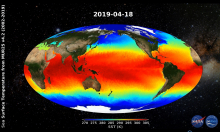 |
GHRSST Level 4 MUR 0.25deg Global Foundation Sea Surface Temperature Analysis (v4.2) Dataset ReleaseThe Multiscale Ultrahigh Resolution (MUR) 1km time series has recently been refactored to add a 0.25 decimal degree spatial resolution analysis known as the GHRSST Level 4 MUR 0.25deg Global Foundation Sea Surface Temperature Analysis v4.2 (MUR25) dataset (https://doi.org/10.5067/GHM25-4FJ42). The MUR25 dataset utilizes the same analysis methodology and input satellite and in situ SST sources (Chin et al., 2017), but provides a much more compact data volume and smoother feature resolution than the original MUR dataset. An aim of introducing MUR25, in addition to the MUR dataset, is to... |
 |
SPURS-2 Field Campaign Third Dataset ReleaseThe SPURS (Salinity Processes in the Upper Ocean Regional Study) project is a NASA-funded oceanographic process study and associated field program that aims to elucidate key mechanisms responsible for near-surface salinity variations in the oceans. SPURS employs a suite of state-of-the-art in-situ sampling technologies that, combined with remotely sensed salinity fields from the Aquarius/SAC-D, SMAP and SMOS satellites, provide a detailed characterization of salinity structure over a continuum of spatio-temporal scales. While SPURS-1 focused on the salinity maximum region of the sub-... |
 |
Oceans Melting Greenland (OMG) Airborne eXpendable Conductivity Temperature Depth (AXCTD) Version 1 Dataset ReleaseOceans Melting Greenland (OMG) is a NASA Earth Venture Suborbital (EVS-2) mission that aims to improve estimates of sea level rise by addressing the question: To what extent are the oceans melting Greenland’s ice from below? OMG observes changing water temperatures on the continental shelf surrounding Greenland, and how marine glaciers react to the presence of warm, salty Atlantic Water. The complicated geometry of the sea floor steers currents on the shelf and often determines whether Atlantic Water can reach into the long narrow fjords and interact with the coastal glaciers. Because knowledge of these pathways is a critical component of... |
 |
Remote Sensing Systems (RSS) SMAP Sea Surface Salinity (SSS) V4.0 Datasets ReleaseThe new RSS SMAP Version 4.0 data spans the full mission, from 2 April 2015 to the present. Enhancement with this version include: 1) an improved land correction allowing retrievals closer to the coast (30-40km), 2) implementation of an improved sea-ice mask based on AMSR2, revised solar flagging, and inclusion of SSS uncertainty fields in the Level 3 (L3) products. Global coverage L3 data products include an 8-day running mean as well as monthly averages. Level 2 swath data are also available as part of the product release. They are available with a latency of 3 days for the Level 2 dataset, and 8 days and 1 month for the respective L3... |
 |
CYGNSS Level 2 Ocean Surface Heat Flux Science Data Record Version 1.0The Cyclone Global Navigation Satellite System (CYGNSS), launched on 15 December 2016, is a NASA Earth System Science Pathfinder Mission that is designed to collect the first frequent space-based measurements of surface wind speeds in the inner core of tropical cyclones. Made up of a constellation of eight micro-satellites, the CYGNSS observatories provide nearly gap-free Earth coverage with a mean (i.e., average) revisit time of seven hours and a median revisit time of three hours. Primarily intended to be an ocean surface wind speed measuring mission, CYGNSS has been measuring science-quality ocean surface wind speed data since the... |
 |
GRACE-FO Level-3 Monthly Ocean/Land Water-Equivalent-Thickness Surface-Mass Anomaly Release 6.0 DatasetsThe Gravity Recovery and Climate Experiment Follow-On (GRACE-FO) mission, a joint partnership between NASA and the German Research Centre for Geosciences (GFZ), launched on 22 May 2018. It uses twin satellites to accurately map month-to-month variations in the Earth's gravity field and surface mass changes. It will continue the legacy data record of the first Gravity Recovery and Climate Experiment (GRACE) mission (2002-2017). Conceptually very similar to the original GRACE mission, GRACE-FO consists of two identical satellites flying in formation around Earth at an initial altitude of approximately 490 kilometers and a nominal separation... |
 |
SPURS2 Field Campaign Second Dataset ReleaseThe SPURS (Salinity Processes in the Upper Ocean Regional Study) project is a NASA-funded oceanographic process study and associated field program that aims to elucidate key mechanisms responsible for near-surface salinity variations in the oceans. SPURS employs a suite of state-of-the-art in-situ sampling technologies that, combined with remotely sensed salinity fields from the Aquarius/SAC-D, SMAP and SMOS satellites, provide a detailed characterization of salinity structure over a continuum of spatio-temporal scales. While SPURS-1 focused on the salinity maximum region of the sub-tropical N. Atlantic, SPURS-2 concentrated on the dynamic... |
IMPORTANT UPDATE: We are in the process of migrating this PO.DAAC website into Earthdata. Thank you for your patience as we make this transition. Read about the Web Unification Project.